How to Do the Cirque du Fer-à-Cheval Trail in the French Alps
The Cirque du Bout du Monde trail, literally “to the end of the world,” is a stunning hike tucked just outside the village of Sixt-Fer-à-Cheval, about an hour north of Chamonix.
It’s also commonly called the Cirque du Fer-à-Cheval trail (“horseshoe” trail), and if you like dramatic waterfalls and wide alpine valleys, this one really delivers.

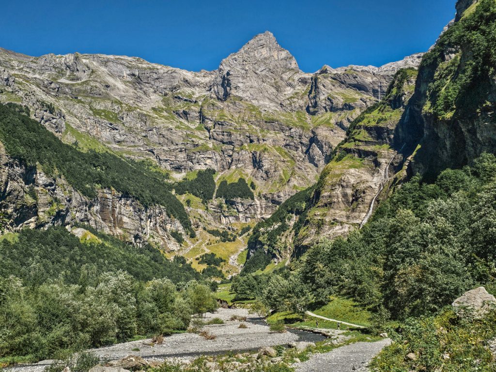
A cirque is a bowl-shaped valley carved by glaciers, with steep walls and a relatively flat floor. The Cirque du Fer-à-Cheval is one of the most impressive examples in Europe.
The limestone cliffs form a huge natural amphitheater stretching roughly 4 to 5 kilometers across, with walls rising 500 to 700 meters. In spring, dozens of waterfalls spill down the cliffs, while in colder months many of them freeze, giving the whole area a very different look.
As you hike, you follow the floor of this glacier-carved valley, with forest and a stream running through the center and towering cliffs on both sides. The trail gradually leads you deeper into the cirque, toward the mountains that close off the valley at the far end. It’s an out-and-back hike with impressive views the entire way.
Read on for all the details you need to make this a smooth hike.
Parking & The Trailhead
The hike begins from the Parking du Cirque du-Fer-à-Cheval lot, a few miles up D907 east of Sixt-Fer-a-Cheval. The lot is big and has a ton of parking, but it is also a popular hike, so it can fill up. There are also spots for RV’s, and you can camp in the area.
There is no fee for hiking, but you will pay for parking; it’s €7. There is also a nice bathroom at the parking lot.
You can also find some spots to purchase food/drink at the trailhead and near the start of the trail.

The Hike
The trail is wide and well-maintained. It follows the river up the valley deep into the dramatic limestone cirque.
You’ll start out walking through the woods by the river until it suddenly opens into the wider valley and you’re greeted by waterfalls everywhere.

You can hike on either side of the river, and the trail is in equally good condition on both sides. The parking lot is on the south side, so it’s the most natural path to follow. We chose to hike on the south side on the way up and the north side on the way down, going counterclockwise.
Of special note are two larger waterfalls around the 2 mile (3.2 km) mark, one on either side of the river. On the “right” side is Cascade du Liaret. On the “left” side is Cascade de la Vogealle.
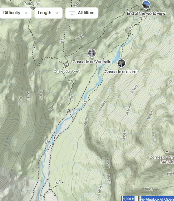
Vogealle is the more dramatic fall, but I almost felt it was best viewed from the opposite bank, just before Cascade du Liaret.


Just past the falls, the two trails on either side of the river combine at a bridge.

From there, it’s just a half-mile push to the final viewpoint. This is the steepest section, with about 700 feet (213 m) of elevation in this short section, but it’s also the most beautiful part of the hike. Keep an eye out for sheep in this area!


The trail ends at the end of the valley (or… ahem… world) with a myriad of beautiful waterfalls surrounding you and a dramatic view back down the glacial valley. There’s also a cave you can climb to and rest in for a moment behind one of the falls.


Optional Extension: Alpine Lake
If you want more adventure, you can continue past the main cirque toward a small alpine lake higher up the valley. This part of the trail just continues from the “end of the world” sign.
The extension adds elevation and time and another 5 miles (8km) round-trip, but it definitely gives more seclusion and some beautiful sights.
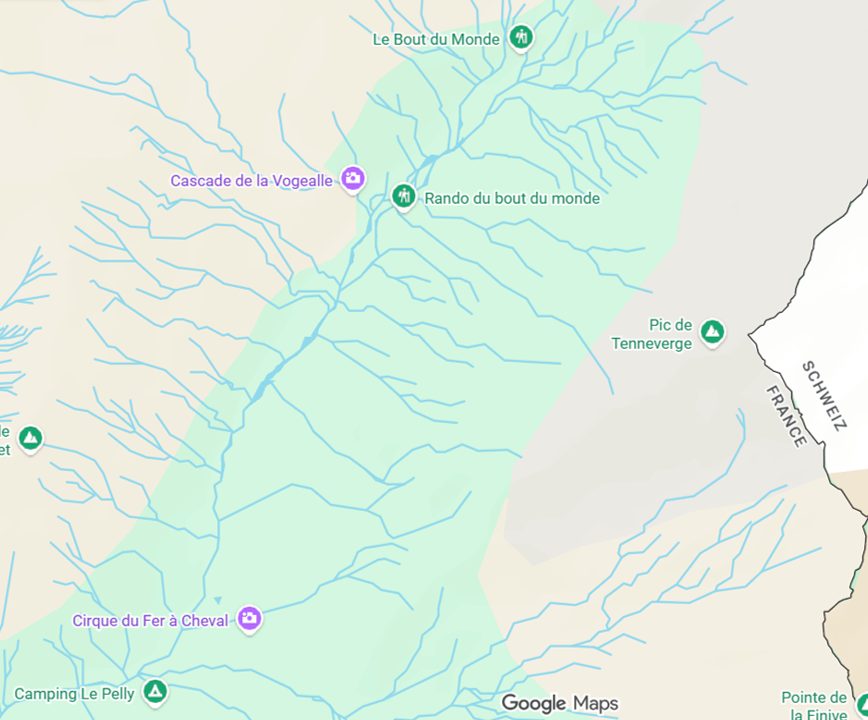
You can also go along this extension as an alternate way to exit the valley. About a mile along this upper trail, you would reach the Chalet du Boret, at which point you can head up to the lake or head back down into the valley. (You can see these spots labeled on the map above.)
Heading Back
We didn’t do the optional extension to the lake, and instead just came back down through the valley via the trail on the opposite side of the river. Despite being just across the stream, this side of the trail did feel distinct. I’m glad we did both sides of the trail, and I’d recommend you do the same as well.


Hike Stats
- 🚶♀️ Distance: 6.5 miles (10.4 km) round trip. It’s 11.5 miles (18.5km) if you choose to go on to the upper lake.
- 📈 Elevation gain: 1300 ft (400 m). It’s another 2000+ ft (609+ m) with the upper lake extension
- ⏱️ Time: 3-4 hours
- 🥾 Difficulty: Moderate. I’d say most of the hike was quite easy, but the final push is hard. And of course, if you add the upper lake, it makes it much harder.
The Village & Nearby Things to Do
Sixt-Fer-à-Cheval is a small but charming hamlet.
Just south of town, you’ll find Cascade du Rouget, a really impressive waterfall right on the side of the road.

Just west of town is the Gorges des Tines. It’s a small, skinny gorge that’s a very short walk from a parking lot, but we weren’t particularly wowed by it.

All in all, though, we really enjoyed this hike (and the surrounding area) and would highly recommend it during your time in the French Alps.
Looking for More Hikes and Experiences in the Alps?
These are some of the other trails and viewpoints we loved in and near Chamonix: